Randonnée Marche La Bouille - La Bouille- Cote Albert Lambert-Robert le Diable - Photo

La Bouille- Cote Albert Lambert-Robert le Diable

 MichelRando7656
MichelRando7656

Utilisateur

© OpenStreetMap contributors
Longueur
Longueur
14,9 km
Altitude max
Altitude max
136 m
Dénivelé positif
Dénivelé positif
291 m
Km-Effort
Km-Effort  
18,8 km
Altitude min
Altitude min
0 m
Dénivelé négatif
Dénivelé négatif
292 m
Boucle
Boucle
Oui
Date de création :
2024-03-17 12:39:12.748
Dernière modification :
2024-03-17 17:03:14.532

(0 Avis)

Marche
Marche
4h23
Difficulté : Difficile

Scannez ce code QR pour ouvrir la randonnée dans l'application SityTrail

Application GPS de randonnée GRATUITE

Logo SityTrail SityTrail

IGN / Instituts géographiques

Télécharger SityTrail sur l'App Store Télécharger SityTrail sur Google Play

Logo SityTrail SityTrail World

Le monde est à vous

Télécharger SityTrail sur l'App Store Télécharger SityTrail sur Google Play Télécharger SityTrail sur Huawei AppGallery

À propos

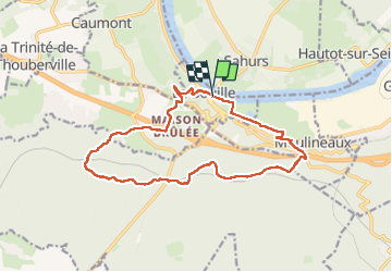
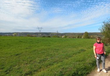
Randonnée Marche de 14,9 km à découvrir à Normandie, Seine-Maritime, La Bouille. Cette randonnée est proposée par MichelRando7656.

Description

Côte difficile Albert Lambert au démarrage . Nombreuses petites routes-
Passage au château Robert le Diable et retour par les marais.

Profil altimétrique

Photos

Localisation

Pays :
France
Région :
Normandie
Département/Province :
Seine-Maritime
Commune :
La Bouille
Localité :
Unknown
Départ:(UTM)
349868 ; 5468584 (31U) N.

Randonnées à proximité

Randonnée Marche Hautot-sur-Seine - Hautot-sur-seine  11km  - Photo
Marche
MichelRando7656

Marche

Moyen
(2)
Hautot-sur-Seine, Normandie, Seine-Maritime, France
11 km | 12,2 km-effort
2h 37min
Oui
Randonnée Marche La Londe - La Londe 76- 13 km - Photo
Marche
MichelRando7656

Marche

Difficile
(1)
La Londe, Normandie, Seine-Maritime, France
13 km | 16,1 km-effort
3h 43min
Oui
Randonnée Marche Saint-Ouen-de-Thouberville - Saint-Ouen de Thouberville- Le Mesnil et la Pierre TTournante  - Photo
Marche
MichelRando7656

Marche

Moyen
(1)
Saint-Ouen-de-Thouberville, Normandie, Eure, France
12,5 km | 15,3 km-effort
3h 35min
Oui
Randonnée Marche Moulineaux - Robert-le-Diable - château - GD - V2 - Photo
Marche
philippe76

Marche

Difficile
(1)
Moulineaux, Normandie, Seine-Maritime, France
10,4 km | 13,1 km-effort
2h 58min
Oui
Randonnée A pied Saint-Pierre-de-Manneville - Du coté du Manoir de Villers - Photo
A pied
JMCMoreau

A pied

Facile
(1)
Saint-Pierre-de-Manneville, Normandie, Seine-Maritime, France
11 km | 12,5 km-effort
2h 45min
Oui
Randonnée Marche Saint-Pierre-de-Manneville - st pierre de mainneville - Photo
Marche
Philippe Auguste

Marche

Moyen
Saint-Pierre-de-Manneville, Normandie, Seine-Maritime, France
7,6 km | 8,9 km-effort
1h 25min
Oui
Randonnée Marche La Londe - 20240402-La Londe - Photo
Marche
doudet

Marche

Difficile
La Londe, Normandie, Seine-Maritime, France
11,6 km | 14,3 km-effort
3h 14min
Non
Randonnée Marche Moulineaux - 20240227-Moulineaux  Cool - Photo
Marche
doudet

Marche

Facile
Moulineaux, Normandie, Seine-Maritime, France
7,8 km | 8,7 km-effort
1h 49min
Oui
Randonnée Marche Sahurs - 20231216-sahurs - Photo
Marche
doudet

Marche

Moyen
Sahurs, Normandie, Seine-Maritime, France
12,8 km | 14,2 km-effort
3h 18min
Oui


Fermer
Mes abonnements